


05 - Barafu Camp - Mweka Camp
05 - Barafu Camp - Mweka Camp
Trail Information
Distance: 17km
Difficulty: Extremely Hard (due to duration)
Transport: None
Terrain: Kilimanjaro spans five ecological zones. Each day progresses through one or more of them.
-
Where people live, work and farm. this is the main altitude of Tanzania.
-
Mountain forests and evergreen. Heavy rainfall and high humidity.
-
The start of lower oxygen and stranger flora. There is little tree cover and the change from rainforest to moorland is both dramatic and obvious.
-
You will see some real changes in your body at this altitude, very few animals and plants live at this level.
-
Hail, snow, freezing winds are all possible. Nothing lives at this altitude. Rocks and stones are your only friends.
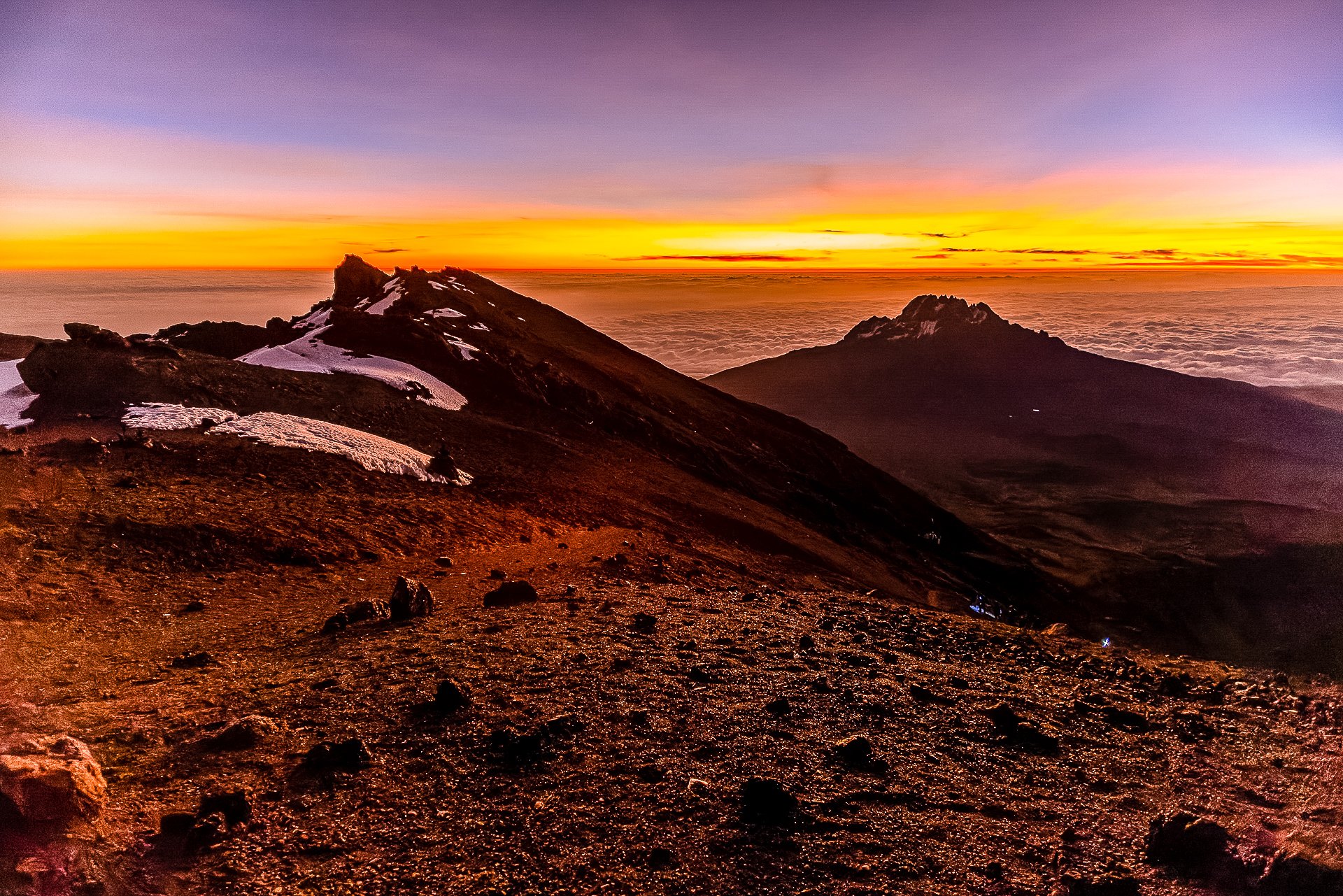
You' start the hike at the edge of the Alpine Desert, after about an hour of climbing in the dark you enter the Arctic Zone, but it is incredibly hard to know when you’ve actually reached this point as you are hiking in darkness and seeing very little but the ground under your feet. By the time the sun rises you’re likely at Stella Point, 756 meters into the Arctic zone, surrounded by rocks, ice and snow.
The way down, the terrain is much more obviously arctic, desolate and rocky.
Accommodation & Shopping
Barafu Camp
Altitude: 4,673 meters

Barafu Base Camp in the clouds
Also called Basecamp, Barafu is a windswept, rocky camp and the highest place you’ll stop unless you are one of the very few people who stay at Crater Base (5,800m). You’ll not be sleeping much here, more resting, which is partly good as the ground is stony and sharp.
The toilets have very small drop holes, but you’ve been practicing your aim by this point so you’ll be fine. They also have small windows with incredible views.
Sights
Stella Point
Sunrise from Stella Point
5,756 meters up, and so 139 meters lower than Uhuru Peak, Stella Point is the incredible viewpoint looking eastwards where you watch sunrise as part of your final summiting climb. The colours are magical as the landscape lights up. Its not widely known, but if you make it here and can’t face the final 139 meter ascension, you’ll still receive your certificate for climbing Kilimanjaro.
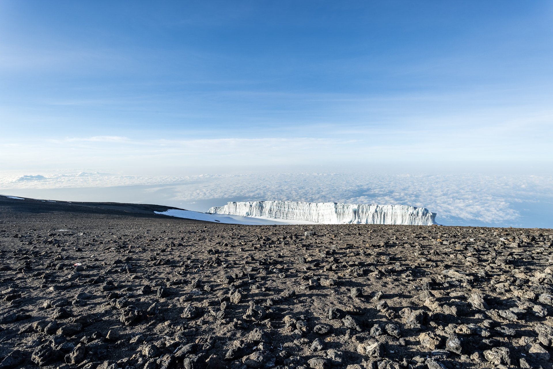
Uhuru Peak

View from Urhuru Peak
At 5,895 meters, it is the highest point on the volcanic peak Kibo on Mt Kilimanjaro, Uhuru Peak is ‘the’ summit of Kilimanjaro and the desitnation for those climbing Kili. The name means ‘Freedom’ in Swahili and was given to the peak in 1961. A wood sigh marks the location, and a crowd of hikers will surround it, getting their picture-proof of reaching the Roof of Africa.
The Experience
Day 5
After seven hours hiking, and a handfull of hours of rest and light sleep, we were woken up at 23:00 buy everyone’s alarms going off at the same time. We were all dressed and ready to go well before our midnight start time, but 23:30 we were mostly sat in the main tent drinking coffee wishing we could get started.
I’d listed to the guides saying how cold it would be and put on four layers. Merino wool base, mid-layer, hiking trousers/fleece and windproof shell. You’d think I’d have learned from my earlier experience that what someone who lives in a 30 degree paradise considers cold is not the same as someone who wore a t-shirt to hike in the arctic circle. But I hadn’t.
We gathered the group. Made sure we had our bags packed and full of water. I asked the guide to carry my camera bag immediately. it was going to be a long route and it weighed more than my backpack. Given it was midnight, I figured it was safe to assume I’d not need rapid camera access.
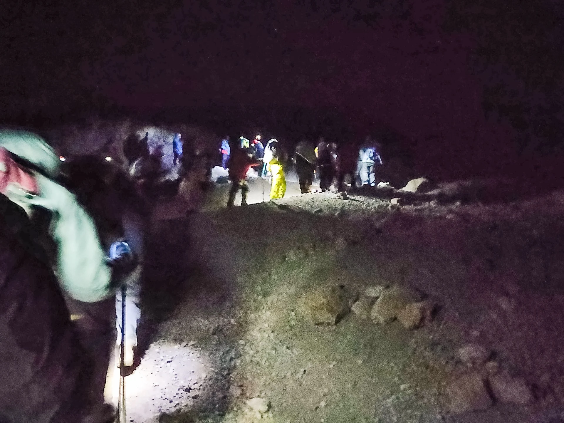
Queue of hikers on Kilimanjaro
At the start of the hike in Barafu camp, there were a lot of groups hiking with us. We formed a long single file queue as we started the trail. Slowly, ever so slowly, we overtook on various wider sections and broke ahead of the pack. By 1am we’d got to the front of the midnight hikers (or at least the ones not massively faster than us.) and so ahead of us was darkness and then a line of head-torches snaking up the invisible mountain.
By 1am I was also melting. We’d not reached the windy parts of the trail, and the guides did tell me it would get colder, but I couldn’t continue with all the layers I had on. At a brief stop, I stripped down to a t-shirt and my winter jacket that I left open and changed from wool had to baseball cap and my gloves went in my pockets.(Gloves going off was a mistake, they slowly got very cold due to the wind. I should have at least had my liners on.) That still wasn’t enough so when we stopped for our first real break at about 2am, I did a bit of a strip tease on the slopes of Kilimanjaro and got down to my pants, before putting a two layers back on. One for basic warmth, one as a wind break.
Editors Note: Don’t just assume you can climb Kilimanjaro in jeans and a t-shirt based on this. It was unseasonably warm, no more than -5 degrees at the summit and the wind was fierce. Listen to the CEOS and make sure you at least carry enough layers to cope with sudden temperature changes.
Its hard to know if its better or worse to not be able to see the peak. The darkness means you are mostly looking at your feet the entire time, and when you do look up, other than lights above you, you have no idea how much remains.


Hour after hours, we put right foot in front of left foot, and left foot in front of right, inching our way upwards in the dark. The trail is good,dusty with lots of rocks around, but stable. Its a series of switchbacks criss-crossing the mountain face and so its not too steep at any one time, but you are walking a much longer distance.
The lights worn by the people ahead is the only indication of what’s coming up.
Half way up, about three and a half hours of hiking, I handed my back-pack over to my supportive guide who already had my camera. Looking back, even with their own gear and most of ours that made it look so much easier that we found it, but the ongoing positivity coming from them kept us moving. I wish I’d kept my water-bottle however, as handing the whole bag over meant I had to ask for water or wait for a break and it reduced the frequency I was drinking. It also didnt help I left the bottle on the outside so the water froze.
Whenever someone asked, and someone was always asking, the guides would tell us we’d see Stella Point ‘soon’. I understand the psychology of it, but personally I’d rather have the bad news, than become disillusioned with the answers. Eventually I started wondering if we’d ever reach Stella Point or if this somehow was a self inflicted Sisyphus.
Incredibly, before we even reached Stella Point, before the sun was more than a lightening of the horizon, we ran into one of our group on his way back down. Someone, despite the altitude and the cigarettes, he’d already reached Stella Point, carried on the hour more to Uhuru Peak, taken his photos (In the dark) and headed back down, past Stella and met up with us. He had to have been at least an hour and a half faster than us over what took us seven hours. Incredible.
As dawn cut a thin red line across the sky, we reached Stella Point, highlighting just how expert our guides were at pacing. I got my camera off of my guide and took some photos, looking back, its clear how tired and emotionally exhausted I was, standing on one of the most incredible viewpoints in the world, looking out at something under a third of a million people have ever seen and I look a handful of images and even relied on Auto for some of them. I didn’t realise then, but I was exhausted and running on will power and the desire, the need, to summit.


The respite from climbing ever upwards was brief, though the juice, water and snacks were an incredible boost for all of us. But soon, we continued, hiking for the first time in what seemed like days in daylight.
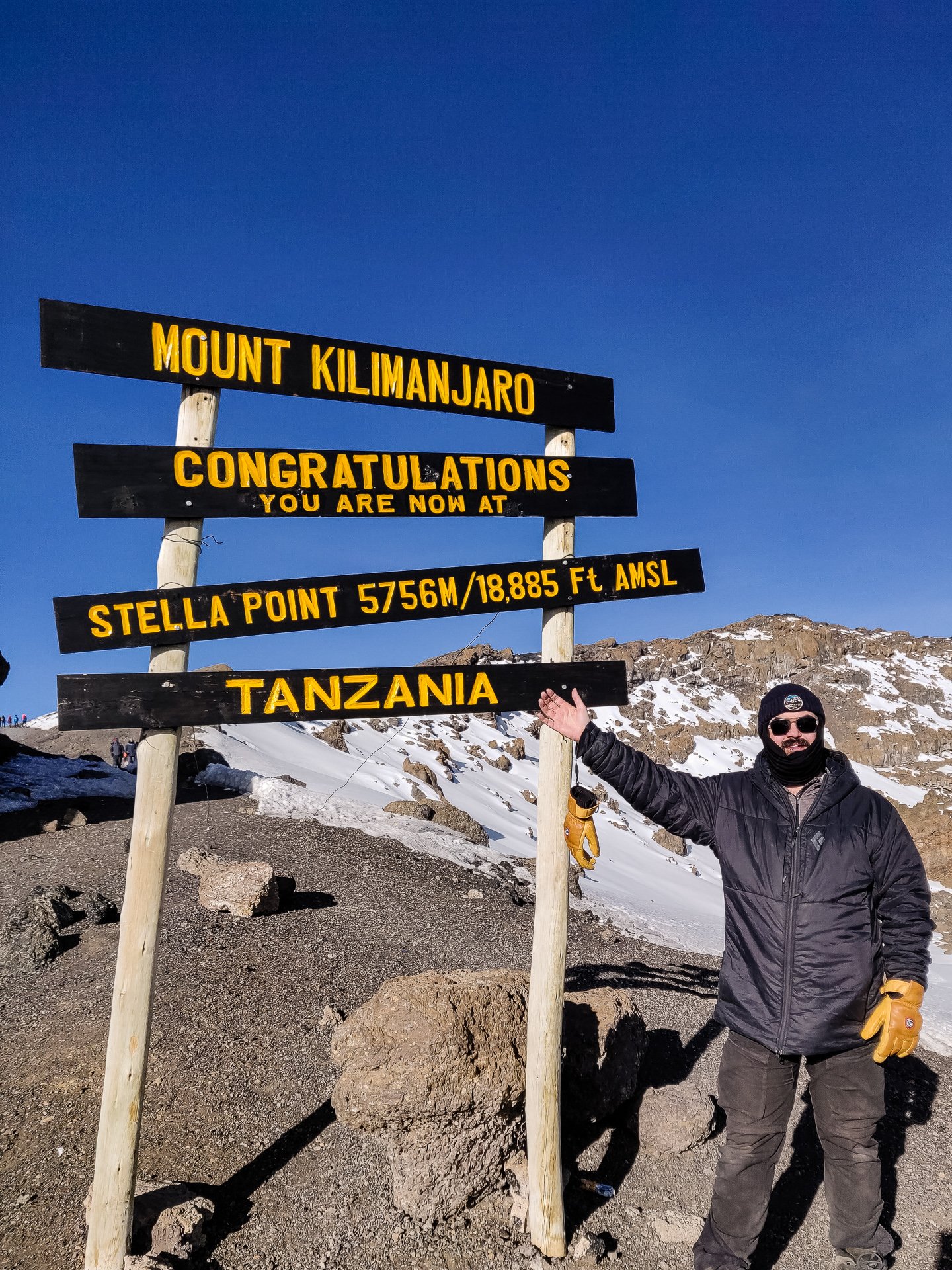
Standing at Stella Point (taken on the return from Uhuru)
From Stella it is an easier walk uphill, some rocks to scale, but generally a gentle uphill hike. you’ll cross a few false peaks before you see Uhuru.
When you finally get there its anti-climactic somehow, no dramatic icy pinnacle like you see in films of daring mountain climbers, but a flat plain of rocks and ice, with a wooden sign post highlighting just what you’ve achieved. Reaching Uhuru Peak, 5,895 meters high. The roof of Africa.


The reason the tours aim for Stella Point for sunrise rather than pushing you to the Peak becomes obvious, there is little visibility back to East, as that is where you hike from, and the views surrounding the peak are lovely, but not quite so impressive.
Naturally everyone wants a photo with the sign, both individually and as a group, and there’s a queue for the opportunity. The guides have some system worked out between them, but an obnoxious older gentleman decided he was in charge and created his own queuing system, which remarkably benefited his large group of forty or so who wanted to take group photos, sub group photos and individual photos. When the guides ignored him, and sent people up, rather than ‘queue on my left’ as he loudly insisted people should do, he got quite upset that his self imposed system he’d created with no authority what so ever was being ignored.

Holding on (at least partly) to stay standing…
We’d done it. We’d reached the summit of Mount Kilimanjaro. I didn’t know it at the time, but I was the 274,525 registered climber to reach Uhuru Peak since record keeping began.

Some of the G Adventures crew at the summit of Mount Kilimanjaro
Seven hours of hiking to Barafu, seven or so to Uhuru Peak and the enormity of what remained before we could sleep hit is all. You could see shoulders slump as we realised we had nothing left to do on the summit and we were crowding the location and so needed to move on. We had perhaps four hours down to reach Barafu where we’d get some food and a few hours rest. The faster you descend the more time you get to rest. Which seems unfair as the slowest need the recovery time. After reaching Barafu we had another four hours hiking downhill to reach Mweka Camp where we’d be staying the night.
We’d reached our goal, achieved something few people in the world have ever done, but were not even two thirds of the way through our “day’s” hike.
The way down was increasingly hard. Almost all of it, at least for the first few hours, is on loose, sharp scree that slips under your tired feet.
I was a lot more tired than I was admitting to myself. At one point I fell, sliding down enough I took the legs out from one of our group and brought him down with me. Luckily he was fine and I had only a few scrapes. Despite this, I still refused to admit I was struggling and was increasingly short with the guides who grabbed at me whenever we were taking a more challenging section.
The downward was steep section after steep section. We paused in a flat area ringed with rocks and I fell trying to sit on one of them, and finally admitted I was exhausted. There was at least two hours left, more downhill, a bit of a flat walk, then an uphill climb and back down hill to where we camped. I drank a lot of water and ate my final protein bar and felt somewhat better, but still not sure how I’d find the energy for the final stretch and the four hours more to come.
It was a long climb down over more scree with close monitoring from my guide who walked with me. Near the end of the downhill, as we finally got a break and a walk along the flats I encountered one of the other members of the team, perhaps the toughest of us all. Unable to keep food down from the second day, she still carried on, day after day and reached the summit and got back down before I did. Incredible endurance. We met on a rock where some of the G Fighters were hanging out with juice for us to restore some energy and to take our bags and gear off of the guides who had been helping us and lighten their load.
Even here, there was still an hour left before getting to Barafu Camp. We had to climb upwards over rocks and then down a very difficult rock face to reach the final trail to the camp.
We finally got into camp together. I stuck my head into the main tent to say hi and congratulations to the many members of our group who’d arrived well before me, told the CEO I’d be skipping breakfast to get some sleep and crashed in my tent.
I managed an hour of sleep over two hours in my tent. I was woken up and asked if I could eat something. Somewhat snarkily replying ‘Yes, I’m not ill, I’m just tired’ I dragged myself up, and had some soup for breakfast, or lunch, or dinner. By this point all sense of time had gone and we were all a bit unclear what meal we were eating. It was then time to do the final hellish descent to where we could finally sleep.
The trail running from Barafu to Mweka Camp is four hours and about seven kilometres. It is also some of the worst terrain you’ll encounter on hiking Kilimanjaro, and not just due to exhaustion. Initially it is not too bad, some downhill clambering on rocks until you get to a fairly nice long flat section. The flat section is mostly scree, but as its not steep, its not too treacherous underfoot. We were hiking like this for about an hour, perhaps an hour and a half before we descended into the Moorland Zone and things got a lot more difficult. The whole process was brutal.
One interesting interlude, from time to time we’d pass strange two wheeled ‘beds’ left by the side of the trail. Turns out they are ‘mountain' ambulences’ injured or ill hikers are strapped to the metal bed, and 6 men run the bed down the mountain at breakneck speeds. Our CEO cheerfully told us no one fakes injury to get out of hiking the final stretch. or at least not for long. If you’ve got any option, you don’t want to be tied down and bouncing on one of those contraptions.


Pretty much the entire 3 hours through Moorland is climbing down, on rocks or on ‘stairs’ that have been created with rocks and concrete but unevenly and with a large gap between them. We stopped three times in the four-five hours it took us to do the hike. First time was by the side of the road after about an hour and a half’s hiking, second time was when we reached High Camp, a place some groups stop at which makes the summit day easier but means a longer hike to finish. and finally about an hour before the end.


This four hours was the hardest thing I’ve ever done. Climbing to Kilimanjaro’s summit was nothing compared to the willpower needed to keep going down these terrible rocks. Seeing High Camp in the distance and then walking through it and knowing there were hours remaining nearly broke my heart.
The very final stretch is better. you know you’re reaching the end when the trail becomes better cared for, wood edging starts to appear and drainage ditches. This final half hour is flatter with less rock climbing. When you finally walk into camp its an incredible feeling, we arrived in mid-afternoon and were incredibly glad for the ‘washy-washy’ bowls of warm water to at least make a basic effort at cleaning off with.
At 6pm we had our briefing for the final days hike, and a general catchup, dinner was at 7, fish and rice and between the distance we’d hiked and the fact we were at a more normal altitude, everyone ate a lot. By 8pm we were all in bed. Almost everyone slept extremely well, despite many issues with being able to sleep during the hike. The one warning we were given is thieves would sometimes come up from nearby villages knowing the hikers would be dead to the world, use a knife to slit the edge of the tent and grab what they good so keep anything valuable away from the edges. Easier said than done in these small tents.
Total Distance: 17km (5km to Uhuru Peak. 12km to Mweka Camp)
Altitude Gained: 1,222 meters to Uhuru Peak. Dropping 2,827 meters to Mweka Camp