Etapp 13 - Kvikkjokk - Tsielekjåkkstugan
Silver ore was discovered close to what is now Kvikkjokk in the 1650s, and shortly after, in 1661, a Luleå silver plant with a smelter was constructed. Almost 400 years later, 18 permanent residents, as well as a larger number of vacationers, make their home here. Perhaps the fulcrum point on the King's Trail sat between the well-serviced north route to Abisko and the wilder section to Ammarnas. Also, from Kvikkjokk, easy transport options exist to Jokkmokk and various other hiking opportunities in the area.
Trail Information
Distance: 12km + 3km Boat
Difficulty: Medium. There are some steep climbs, but the trail is good.
Transport: Mandatory Boat. Running at 10 am and 2 pm, the boat costs 250kr and can be paid via Swish. An older local man, Bjorn, and his partner, an artist from Upsala, run the boat trips. Depending on the weather and how busy they are, you may get a little tour of the delta and, in my case, a water plant to chew on for some vitamin D.
There is no rowboat option here.
Resupply: The shop is much smaller than the one in Saltoluokta and does not offer any of the 'frills' like clothing, souvenirs or similar, but as Kvikkjokk Fjällstation is in partnership with STF, but not owned and operated by them, they have a different assortment of goods to try, which makes a nice change by this point on the trail.
Given the good bus transport from Kivkkjokk, it is quite possible to take a day trip into Jokkmokk however to do some re-supplying at the larger stores.
Accommodation & Shopping
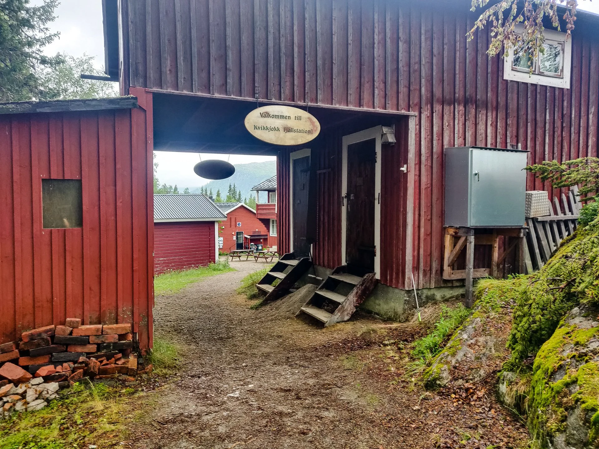
STF Kvikkjokk Fjällstation
The Mountain Station is a strange mix of hotel and cabins. Built-in a traditional style around a central courtyard offers a wide selection of room types or camping on the grounds using a shared kitchen. If you stay in the rooms, you'll have access to the showers and a sitting room with views over the rapids and the mosquito room, a netted outdoor terrace on the first floor.
As a Mountain Station, Kivkjokk is a location you can post supplies to yourself for collection. Like Saltoluokta, make sure you call ahead to get the correct details and confirm which services deliver to the station. I met at least one person who had to take the bus into a different town to collect an errant parcel.


The restaurant offers breakfast, lunch and dinner, though, during corona times, you'll need to book in advance. I had all three meals there, and they were fantastic. The dinner, in particular, is worth the reasonably high price. Lunch was meatballs, freshly made from local ingredients. Dinner was cucumber water with hard bread and salted butter. Souvas as a starter a smoked reindeer dish served on charred unleavened bread. The meat was rich and gamey and smelled of campfires. Then Renfile as a main. It was tender with excellent potatoes and generous portions. Dessert was a luxurious chocolate mousse.
As a village with a road and bus service and a long history as a silver mining location, and a current spot as a key hub on many hiking trails, Kvikkjokk has reasonable transport accessibility, particularly into Jokkmokk.
Slatan
An emergency cabin near to the dock where Bjorn will drop you off from Kvikkjokk has all the facilities you've come to expect by this point, as well as an emergency phone, as from this point, you are out of contact with the SFT rangers and hosts.
Sights
Kvikkjokk kyrka

Kvikkjokk kyrka
Built in 1906 by Gottfrid Svensson, Kvikkjokk church is the centre of this tiny village. On the route between the Mountain Station and the boat and its entranceway is also the bus stop, it's hard to miss and shame if you did.
Off to one side, an external belfry, common in Scandinavia, can be seen.
Side Trails
Lots of options, other than the King's Trail, can be found in Kvikkjokk. The mountain station can help with advice on hiking in the Sarek and Padjelanta areas.
The Experience
Day 11 - 29th:
I reached the Fjallstation by 10:30, so I had four hours before I would be able to check-in and perhaps a bit more before my friend would arrive. I did find the hikers I'd met in Aktse around the communal table in the main building, who was ending here and had a few hours to kill before their transport home.
I also met up with the guy I'd spoken to in the emergency cabin earlier, who had been doing impressive distances every day. He'd headed into Jokkmokk for supplies the day before, explaining how I'd caught up with him. He mentioned that he'd been told the section of the trail we'd just done, from Parte to Kvikkjokk, was currently the worst on the Hemavan-Parte route, which was nice to know.
I had repacked slightly on the way to Kvikkjokk, moving my medical supplies out to the top of my bag rather than the belt pouch and turning the pouch into my mosquito repellant and mosquito hat would be stored for easy access during the hiking day without taking my bag off.
The weather was looking promising from the internet and printed reports on the wall of the Mountain Station. An evening and morning of rain about halfway, but otherwise good weather.
I called the boat driver, Bjorn, who was extremely helpful and was told I could pay him or his partner by Swish when I saw them at 10 am for the crossing.
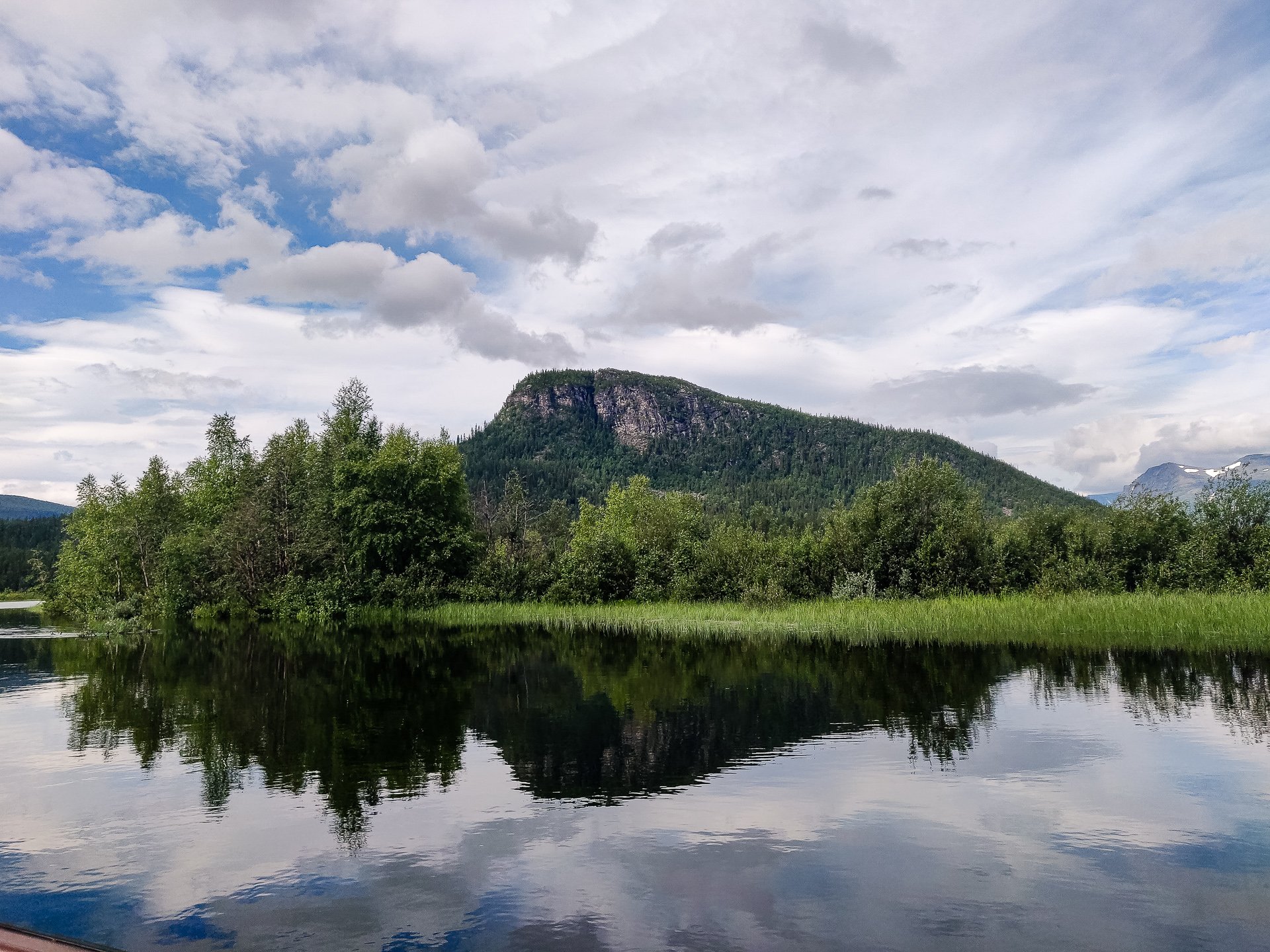
River views
The Mountain Station is sat on a slight hill next to a wide fast river. You can arrange to Kayak from the boat station if you want to take the time. My friend, after she'd had some lunch, was nice enough to take me on a short car trip to a nearby petrol station at a campsite in hopes of getting an extra USB charger. There was no luck there, but we did get to see how the other half camps—a beautiful location with high-quality souvenirs and an elegant bar. When we got back to Kvikkjokk, I found out a charger was available at the reception that I could borrow.
I reviewed my plans and realised the section between Adolfstrom and Ammarnas was going to be tough if I wanted a full day in Ammarnas. Even if I took the boat, it would be three consecutive 17km and still 10km into Ammarnas. This assumes the map is accurate as there may be another 4km according to Gaia GPS compared to the maps. Other than that section, it is a reasonably relaxed two weeks remaining.
The history of Kivkkjokk is fascinating. It started as a forced labour Silver Mine and is now a minor tourist hub for hiking. Kikkkokk has 18 permeant residents and a beautiful church.
The next stage made me nervous. The distance is less than I've come from Abisko, and I've given myself more time to do it in, but the lack of huts, both as symbols of progress and as a refuge in an emergency, worries me a little.
A staff came to me that morning, waiting for the North/South sign on the trail. I had ignored the tent pegs I saw outside of Abiskojaure and ended up needing one. I ignored the duct tape in Saltaulokta and ended up needing it and so chose not to ignore the staff and spent some time outside with my knife starting its shaping.
Tomorrow was expected to be tough. It is a long uphill segment, one of the worst, but still, nothing compared to an Aussie friend of mines recent 10k distance with a 1km ascension.
Approx: 6km
Total 171km (44%)
Head Music: Survivor - Destiny's Child
Day 12 - 30th:
Up at 7:40 and straight in for breakfast, which was fantastic. Due to Corona, it was pre-booked, and I had to request regular milk rather than the Swedish sour milk for the muesli. I packed my bag, and it was as full as I had seen it, as this was the longest stretch without resupply and resupply options until I reached Jakkvik. There were scales outside the reception building, and my bag came in at 17kgs.
I was feeling apprehensive but ready. The extra charger I borrowed helped calm me a little, being confident everything was at 100% before I left.
The boat drivers are a lovely couple; she has a local exhibition of her art in the church cottage and is from Uppsala. He's local and has lived here his whole life.

Bjorn and his boat
The trip included a view of the Kvikkjokk rapids, which are impressive and have only ever had four kayakers complete them safely. He also stopped off near his house to refuel and gave me a water plant to gnaw on, saying it was a good vitamin C source. It tasted and had the texture of celery but a bit more bitter.

Mountain views
Much of the water coming into the lake through the various rapids and streams is glacier milk, which comes from glacial run-off and contains small rock particles.
The mooring point juts out, far into the water, with more mooring than they could need. It was currently largely underwater due to the heavy rains and melting snow.

Start of the 'wild' Kungsleden
Once you pass the Slatan emergency shelter, the first three kilometres are through a marsh. I managed to fall off the plank walkway and straight into the swampy water. Not an ideal situation immediately after leaving civilization. Once I got to a point where it was dry again, I changed socks to a dry pair to reduce the blisters' risk, as nothing causes them faster than wet socks and wet shoes.
Leaving the marshland, the trail starts heading uphill, fairly gently. Another two kilometres in or so, you come to a beautiful forest, and you already have the sense that this trail is wilder and less taken than the previous tracks.
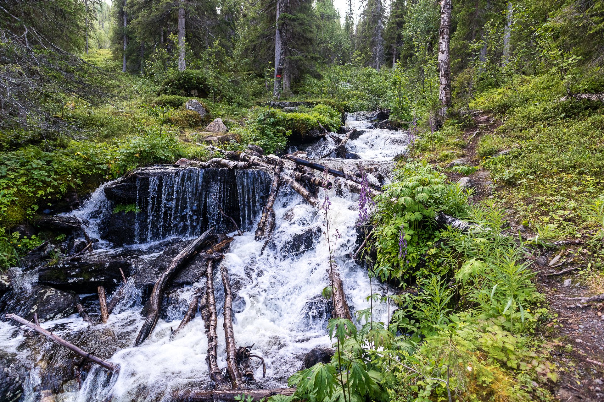
Waterfall
At one point, you climb over some rocks across a spectacular waterfall. After this, I met my first travellers on this trail, heading north to Kvikkjokk and who' have a few hours wait for Bjorn at the shelter. From there, its a tough but good climb steadily uphill.

Grasslands
I stopped for lunch at 1 pm, on a flat rock. The trees were beginning to give way and were much shorter this high, with periods of plains or marshland. The views around you are of Sarke National Park.

Grass leading to the mountains
By lunch, I had passed four people heading north to the Kvikkkokk crossing, but I knew I was the only one going sound for a good distance. Anyone on the later boat was hours behind me and not even on the crossing yet, and anyone who'd crossed the day before was a day ahead. It was almost silent as I wrote in my journal after lunch, occasional birdsong or insects the only thing breaking the peace.

Spectacular views in the wilderness
The trail continues through the forest until you break out into the water's edge and see the metal bridge crossing a wide river and Tsielekjåkkstugan emergency cabin on the far side on the high ground.