Etapp 20 - Aigert to Serve
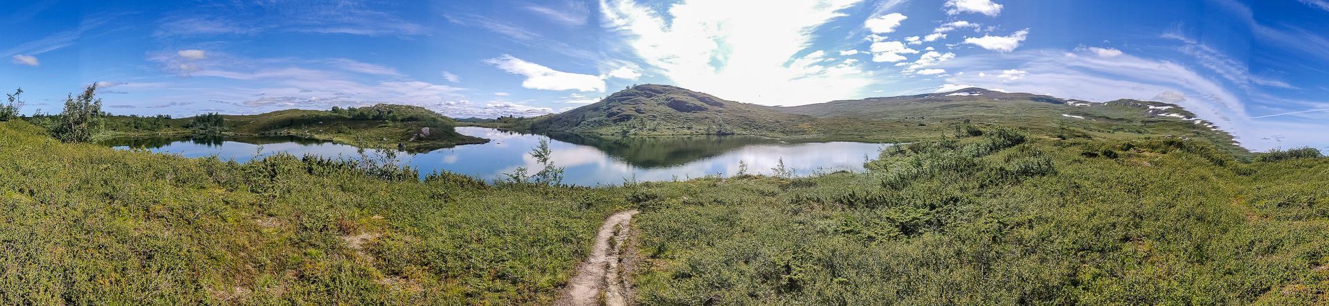
Lush grassland gives way to rocks and pools as you climb ever higher on the trail from Aigert to Serve. This section has the highest point and the steepest ongoing climb of the Southern part of the King's Trail (Tjäkta being the highest overall). After reaching the emergency cabin at Juovvatjåhkka, you have a fast climb down before a shorter hump and an eight-kilometre gentle descent to reach Serve.
Trail Information
Distance: 19km
Difficulty: Hard
Transport: None
Resupply: STF Aigertstugan has a medium-sized supply store, offering the normal STF options of dried foods, beverages and snacks. As it's so close to Ammarnäs, it's something of a surprise it has anything for sale.
Accommodation & Shopping
STF Aigertstugan

STF Aigertstugan
The first STF on this portion of Kungsleden, Aigertstugan, is set in a lovely location between two lakes and has several cabins. Its proximity to Ammarnäs is a strength and a weakness as it's close enough many won't stop here, but also close enough it's an option for weekend trips and has a good resupply setup.
Juovvatjåhkka
A small emergency cabin at the highest point of the southern Kungsleden. Stove, drop toilet, and benches are available to use.
Vuomatjåhkka
A couple of kilometres past Juovvatjåhkka, this hut also offers a drop toilet and a cabin to shelter in. Unlike Juovvatjåhkka, it is slightly off the main trail, though only a few hundred meters.
Sights
Aigert Lakes
Aigert Lakes
On either side of Aigertstugan, two lakes offer lovely views, and one is for drinking, the other swimming.

Aigert Bathing Lake
The Experience:
Day 23 - 10th:
Aigertstugan is a large STF cabin set up with a tiny roomed shop. (Supplied by helicopter) It also offers plenty of beds for travellers. The host had been there since 18th July and mentioned that the week I was there was the best weather they'd had.
I stopped for lunch, and the host returned from her hike whilst I was eating, and I was able to get my patch for this cabin. As I ate, I spoke with two hikers heading the other way, who told me the next 18 kilometres were the most beautiful on the trail. With good weather to hike in, I was looking forward to finding out if that was true.

Onwards and upwards
From Aigertstugan, it is consistently uphill. Not too steep, but for quite a few kilometres. It is lush and green at the lower end of the trail, changing to sparser rocks and scrub grasses as you reach the summit. Ensure you're well supplied on the water before venturing too far from the Cabin as there is no flowing water on the tops of this trail, only large lakes. (which you can, of course, purify).
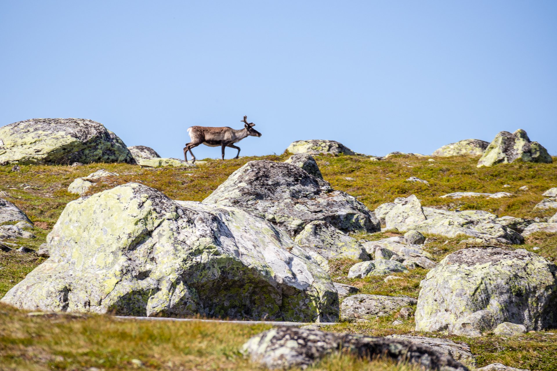
My first reindeer
Reaching the top of the trail near to the top of Lila Aigert, I saw my first reindeer. All alone, wandering up the hill. It was exciting, and I followed him for a little as it was the first real wildlife I'd found.

Mountain Lake
From there, it a further limb, over a lot of rocky patches but some gorgeous mountain lakes before you reach the highest point south of Kvikkjokk, with an emergency cabin and a drop toilet. Whilst there, I met a couple who were going a similar distance and started a few days after me, who had paused at the summit for a break.
Below the highest point, it gets scrubby and muddy. Despite the map, the main river was small and not flowing well. I walked further on and hi hill a little, finding three small streams to get water, and then spotted a nice, reasonably flat space on an outcropping to set up my tent and make the most of a great view. After twenty minutes or so, when I was set up and having a snack in my tent, I heard a strange noise. Like a toad but so loud it would have to have been almost in my tent. Occasionally the sound of a bell would clang.


I walked out and noticed, running across the hill facing me, hundreds of reindeer. Brown, black and white hide; they ran down the hill and into the field near me. Honking. Their bells ringing as they grazed the grass. After a short time, they turned around and rushed back to wherever they came from. I sued quite a few of my remaining photos here and was finally glad of my zoom lens.
An hour or so later, they were back in a different field. An hour or so after that, they returned, even closer to my tent as I was eating dinner.
Approx: 19km
Total: 358km (86%)
Day 24 - 11th:

Woodpecker
An 8:50 start to the day and an easy trail through the hills. You pass another hut, Vuomatjåhkka, you can pause at. It's slightly off the main trail but very visible and on a reasonable sized river for water.
After Juovvatjåhkka, there is another climb for a short time and about an eight-kilometre gentle descent to the STF cabin STF Serve.
Approximately 2 kilometres before the cabin, you cross a large bridge over a fast river, Servvejuhka. Quite a few people appear to have camped in the past just before the bridge, so there are well-worn campsites. The trail is mostly beech forest with some marshland, but it's in good condition.
On my way, I noticed there were more birds around than I'd seen before as well and even stopped a woodpecker and a hawk with white-tipped wings.
The STF cabin is slightly off the main trail, a T junction in the forest, well signposted, marks it with a wood bridge crossing a small stream to get there.